
This Istanbul tourist map shows where the main sights lie, so you can see at a glance which are close together and which are across the water. The old city sits on a peninsula between the Golden Horn and the Sea of Marmara. Beyoğlu and Beşiktaş lie north of the Golden Horn, and Kadıköy and Üsküdar are on the Asian side of the Bosphorus.
Last checked: 10 November 2026. The base map uses OpenStreetMap coastline data, and the numbered markers are our own. Marker positions are approximate, so use an online map app for exact directions.
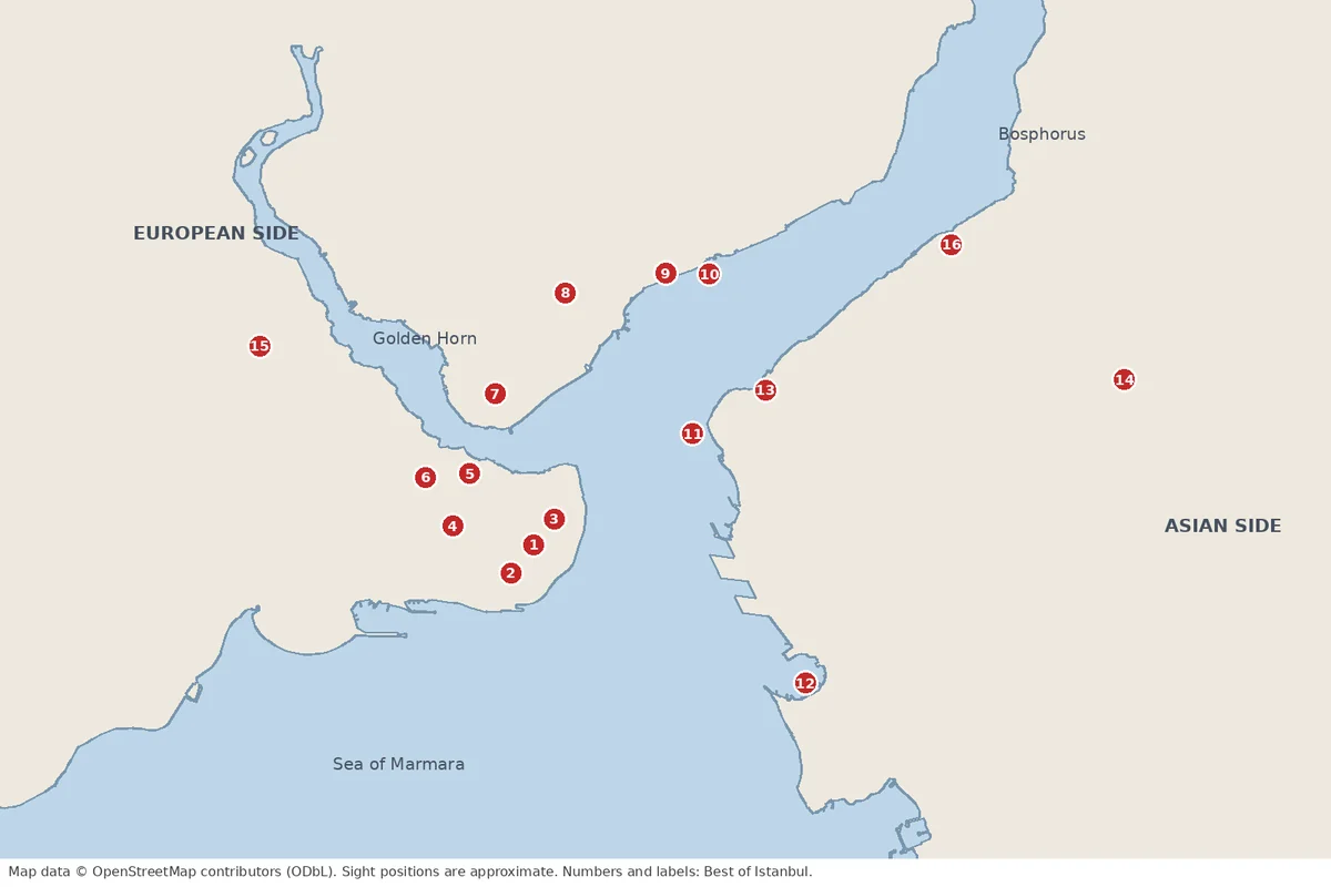
Istanbul tourist map: key to the numbers
| No. | Place | Area | Our guide |
|---|---|---|---|
| 1 | Hagia Sophia | Sultanahmet | Tickets |
| 2 | Blue Mosque | Sultanahmet | Visit rules |
| 3 | Topkapı Palace | Sultanahmet | Palace guide |
| 4 | Grand Bazaar | Beyazıt | Bazaar route |
| 5 | Spice Bazaar | Eminönü | Bazaar route |
| 6 | Süleymaniye Mosque | Fatih | Mosques |
| 7 | Galata Tower | Karaköy and Galata | Tower guide |
| 8 | Taksim Square | Beyoğlu | Hills guide |
| 9 | Dolmabahçe Palace | Beşiktaş | Palaces |
| 10 | Beşiktaş Park stadium | Beşiktaş | UEFA final |
| 11 | Maiden’s Tower | Off Üsküdar | Maiden’s Tower |
| 12 | Kadıköy pier | Asian side | Kadıköy guide |
| 13 | Üsküdar pier | Asian side | Üsküdar guide |
| 14 | Büyük Çamlıca Mosque | Asian side hills | Mosques |
| 15 | Kariye (Chora) | Edirnekapı | Kariye guide |
| 16 | Beylerbeyi Palace | Asian shore | Beylerbeyi |
How the city is laid out
- The old city (Sultanahmet). Hagia Sophia, the Blue Mosque and Topkapı (1, 2, 3) stand within a short walk of one another. The Grand Bazaar (4) lies slightly west.
- Eminönü and the Golden Horn. The Spice Bazaar (5) sits at the water. The Galata Bridge links it to Karaköy.
- Beyoğlu. Galata Tower (7) and Taksim (8) are on the hill north of the Golden Horn.
- Beşiktaş. Dolmabahçe Palace and the stadium (9, 10) are along the European shore of the Bosphorus.
- The Asian side. Üsküdar and Kadıköy (12, 13) face the old city across the water, and the ferry crosses in minutes.
How to get between the sights
| Route | Best way |
|---|---|
| Sultanahmet to Eminönü and Karaköy | T1 tram. See our transport guide |
| Karaköy to Beyoğlu | The Tünel funicular, or walk up |
| Kabataş to Taksim | F1 funicular |
| European shore to the Asian side | Ferry. Prices are in our fare comparison |
| Airport to the centre | See our airport guide |
Which area to stay in
Choose Sultanahmet for the old city, Beyoğlu or Galata for evenings and the funicular, and Kadıköy for local life. See our best areas to stay for a full comparison.
Which Istanbul tourist map to carry on the ground
Download an offline map of Istanbul before you travel, so you can navigate without mobile data. Our photo spots map adds viewpoints with exact locations.
Istanbul tourist map: quick answers
Which side is Sultanahmet on?
The European side, on the peninsula between the Golden Horn and the Sea of Marmara.
Is the Asian side far from the old city?
Not by ferry. The crossing from Eminönü or Karaköy to Kadıköy or Üsküdar takes a short ride.
